-
-
Capital: New Delhi
-
National anthem: Jana Gana Mana
-
Official languages: Hindi, English
Capital: New Delhi
National anthem: Jana Gana Mana
Official languages: Hindi, English
GEOGRAPHY OF INDIA:
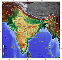
India comprises the bulk of the Indian subcontinent, lying atop the Indian tectonic plate, and part of the Indo-Australian Plate. India's defining geological processes began 75 million years ago when the Indian plate, then part of the southern supercontinent Gondwana, began a north-eastward drift caused by seafloor spreading to its south-west, and later, south and south-east. Simultaneously, the vast Tethyn oceanic crust, to its northeast, began to subduct under the Eurasian plate. These dual processes, driven by convection in the Earth's mantle, both created the Indian Ocean and caused the Indian continental crust eventually to under-thrust Eurasia and to uplift theHimalayas. Immediately south of the emerging Himalayas, plate movement created a vast trough that rapidly filled with river-borne sediment and now constitutes the Indo-Gangetic Plain. Cut off from the plain by the ancient Aravalli Range lies the Thar Desert.
India comprises the bulk of the Indian subcontinent, lying atop the Indian tectonic plate, and part of the Indo-Australian Plate. India's defining geological processes began 75 million years ago when the Indian plate, then part of the southern supercontinent Gondwana, began a north-eastward drift caused by seafloor spreading to its south-west, and later, south and south-east. Simultaneously, the vast Tethyn oceanic crust, to its northeast, began to subduct under the Eurasian plate. These dual processes, driven by convection in the Earth's mantle, both created the Indian Ocean and caused the Indian continental crust eventually to under-thrust Eurasia and to uplift theHimalayas. Immediately south of the emerging Himalayas, plate movement created a vast trough that rapidly filled with river-borne sediment and now constitutes the Indo-Gangetic Plain. Cut off from the plain by the ancient Aravalli Range lies the Thar Desert.
The original Indian plate survives as peninsular India, the oldest and geologically most stable part of India. It extends as far north as theSatpura and Vindhya ranges in central India. These parallel chains run from the Arabian Sea coast in Gujarat in the west to the coal-richChota Nagpur Plateau in Jharkhand in the east. To the south, the remaining peninsular landmass, the Deccan Plateau, is flanked on the west and east by coastal ranges known as the Western and Eastern Ghats;[ the plateau contains the country's oldest rock formations, some over one billion years old. Constituted in such fashion, India lies to the north of the equator between 6° 44' and 35° 30' north latitude[e] and 68° 7' and 97° 25' east longitude.
EAST INDIA TOURIST PLACES
WEST INDIA TOURIST PLACES
SOUTH INDIA TOURIST PLACES
NORTH EASTERN INDIA TOURIST PLACES
INDIA UNION TERRITORIES TOURIST PLACES


0 comments :
Post a Comment